At Chambers, we provide comprehensive slope stability assessments to identify risks and design effective solutions. Our expert evaluations keep slopes, embankments, and related structures safe and reliable, protecting both people and investments. Using advanced modeling and cutting-edge analysis, we deliver clear, actionable insights to help you make confident decisions throughout design and construction.
What We Do
Our slope stability assessments services are designed to:
Recommend Remedial Solutions
Develop effective strategies to mitigate risks and enhance slope stability.
Model Stability
Use advanced computational models to simulate slope behavior under various conditions.
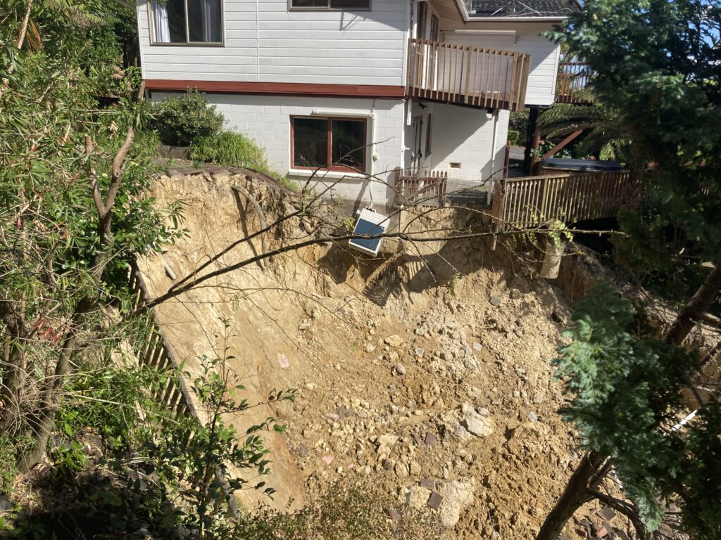
Identify Risks
Evaluate the inherent hazards associated with slopes and embankments.
By understanding the unique geological and environmental factors of your site, we tailor our approach to ensure the long-term stability and safety of your project.
Our Key Services
Risk Analysis
We begin by assessing the potential hazards:
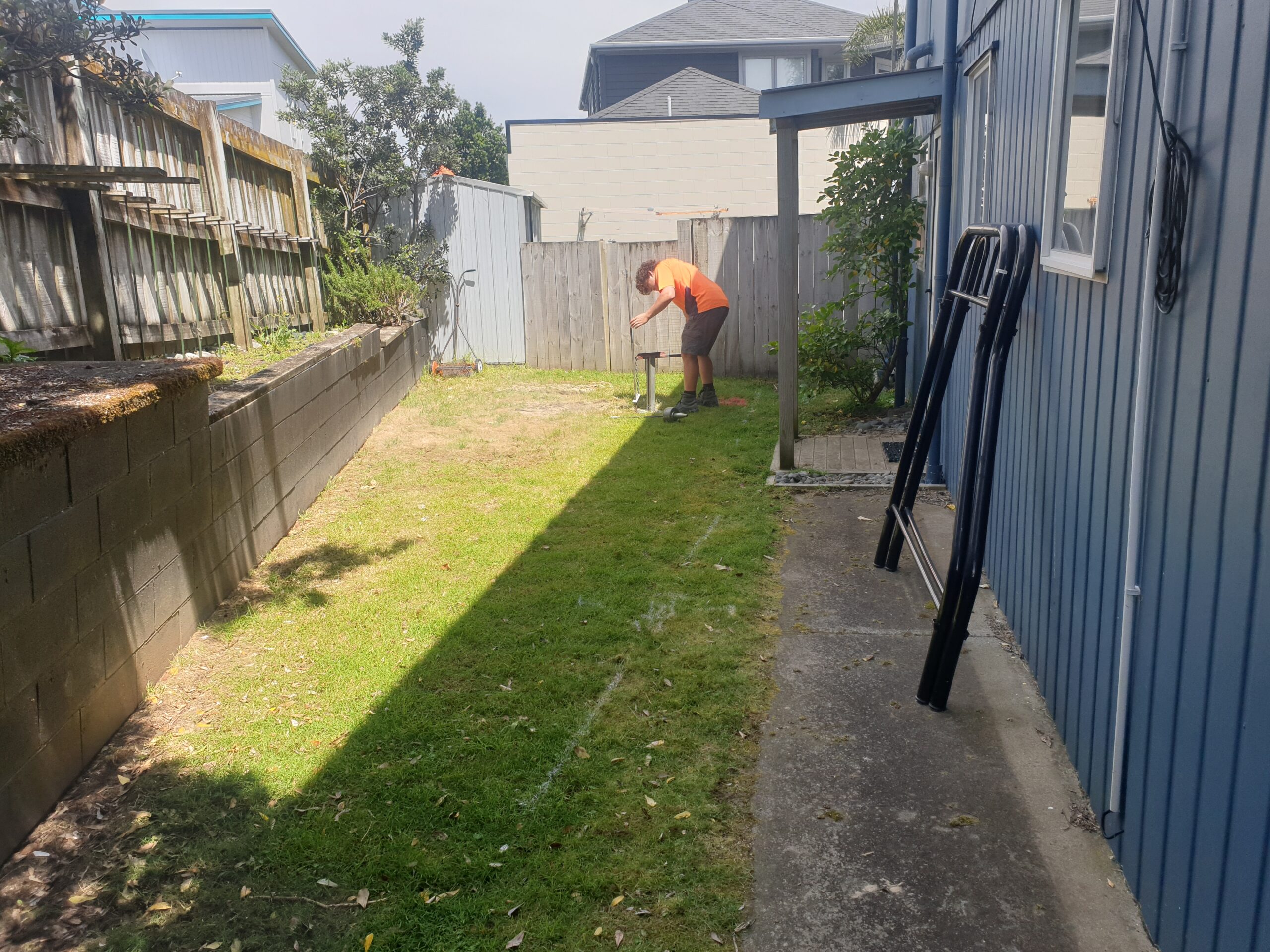
Site Evaluation: Detailed inspection and mapping of slope geometry, soil conditions, and existing vegetation.
Historical Data Review: Analysis of previous incidents, rainfall patterns, and seismic activities that may influence slope behavior.
Hazard Identification: Pinpointing zones susceptible to erosion, landslides, or other destabilizing factors.
Risk Ranking: Quantifying potential risks to prioritize areas for further analysis.
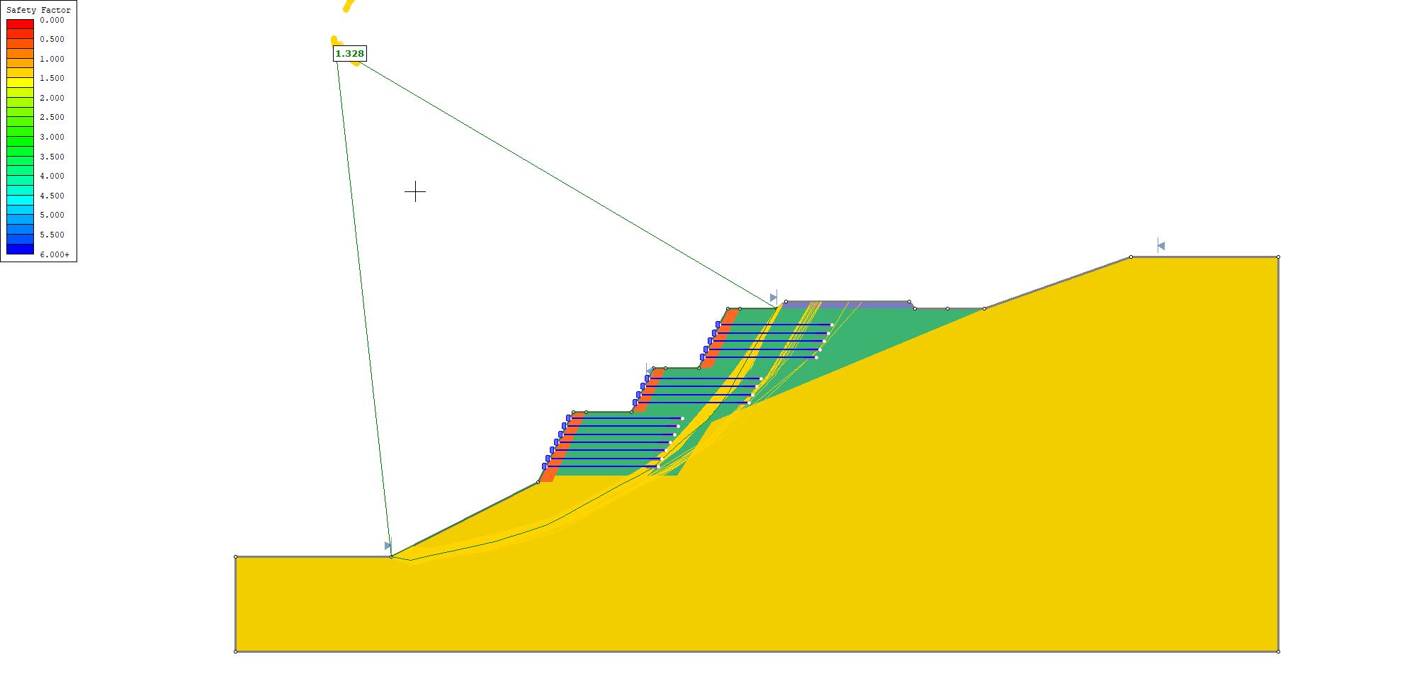
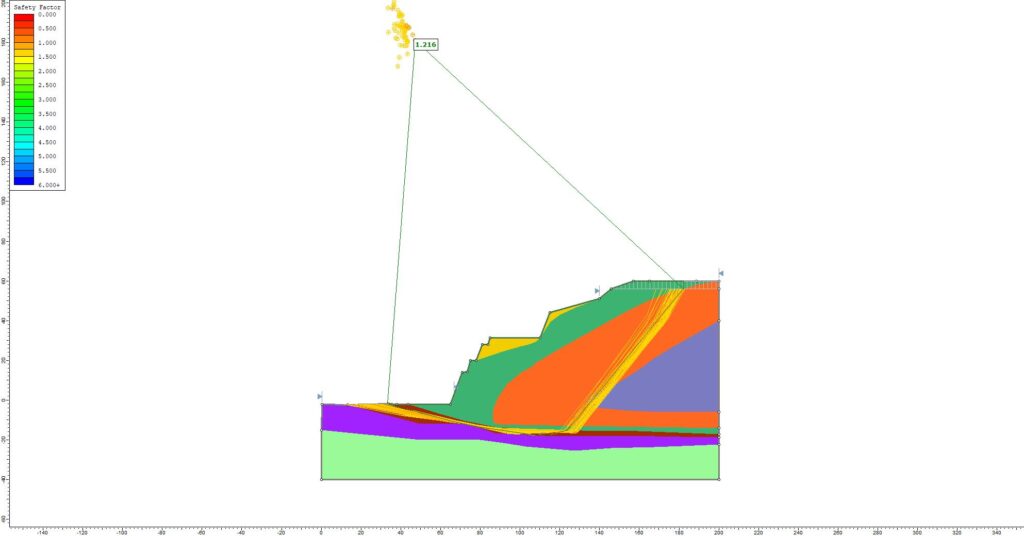
Stability Modelling
We simulate and predict slope performance under various scenarios:
Geotechnical Analysis: Evaluating soil strength, cohesion, and friction angle using laboratory data and in-situ tests.
Computational Modeling: Using advanced software to simulate slope behavior under static and dynamic loads.
Scenario Testing: Analyzing the impact of natural events (e.g., heavy rainfall, earthquakes) on slope stability.
Safety Factor Calculation: Determining the factor of safety to gauge the likelihood of slope failure.
Remedial Solutions
We develop customized solutions to enhance slope stability:
Design Recommendations: Proposing drainage improvements, retaining structures, or vegetation strategies to stabilize slopes.
Engineering Interventions: Outlining construction methods for soil reinforcement, rock bolting, or anchoring systems.
Monitoring Plans: Suggesting installation of instrumentation for continuous slope monitoring and early-warning systems.
Cost-Benefit Analysis: Balancing remediation options with project budget and long-term maintenance needs.
How We Do Our Slope Stability Assessment Services
Our structured approach ensures that every slope stability assessment services is accurate, comprehensive, and actionable:
3. Data Analysis
Laboratory test results and field data are integrated into sophisticated modeling software.
2. Field Investigation
Our team conducts detailed site surveys, collects soil samples, and documents slope characteristics.
1. Initial Consultation
We discuss your project objectives, site-specific concerns, and historical context.
6. Reporting & Follow-Up
We deliver comprehensive reports with actionable insights and offer ongoing support for implementation and monitoring.
5. Solution Development
Based on our findings, we develop tailored recommendations and remedial strategies.
4. Risk & Stability Evaluation
We simulate various loading and environmental scenarios to determine the slope’s factor of safety.
Innovation & Technology
We leverage the latest tools and technologies to enhance the accuracy and reliability of our slope stability assessments services:
Simulation Software
Advanced Simulation Software
Advanced Simulation Software
State-of-the-art modeling tools provide detailed predictions of slope behavior.
Remote Sensing & Mapping
Remote Sensing & GIS Mapping
Remote Sensing & GIS Mapping
High-resolution aerial imagery and geographic information systems allow for precise site characterization.
Real-Time Monitoring
Real-Time Monitoring
Real-Time Monitoring Instruments
Innovative sensors and data loggers enable continuous tracking of slope movement and environmental changes.
Automated Data Integration
Automated Data Integration
Automated Data Integration
Cutting-edge software facilitates seamless integration of field data and laboratory results for comprehensive analysis.
Sustainability & Impact
Our approach to slope stability is not only focused on safety but also on sustainable development:
Preventative Risk Management: Early detection and remediation help avoid costly repairs and environmental damage.
Long-Term Durability: Remedial solutions are designed to provide lasting stability, reducing future maintenance and intervention needs.
Environmental Protection: Sustainable engineering practices minimize the ecological footprint while enhancing natural stabilization processes.
Community Safety: Effective slope management protects infrastructure and lives, contributing to resilient, thriving communities.
Industries We Serve
Our slope stability assessments services support a wide range of sectors:
Government & Municipalities
We help public agencies assess and mitigate risks for highways, public works, and community infrastructure projects.
Residential & Commercial Developments
Our evaluations ensure that new developments are built on stable ground, reducing liability and enhancing long-term value.
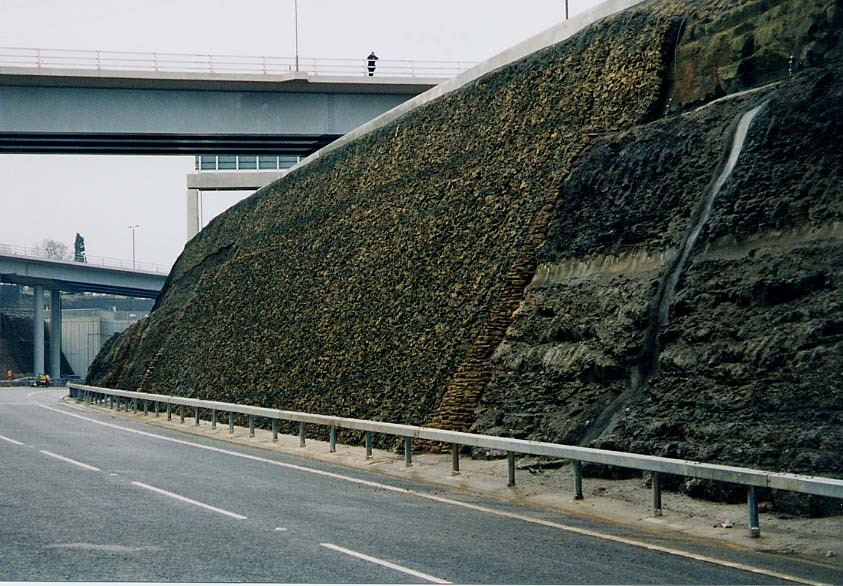
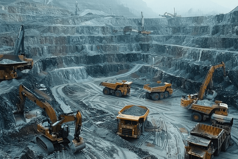
Industrial & Mining Operations
Our expertise safeguards critical infrastructure in industrial and mining environments where slope stability is paramount.
Transportation & Infrastructure
We support the design and maintenance of roads, railways, and embankments, ensuring safety and reliability under diverse conditions.
Environmental & Remediation Projects
We assist in environmental restoration projects by identifying and mitigating natural hazards, promoting sustainable land use.
Why Slope Stability Assessments Services are Important
Slope stability assessments services are a critical component of risk management in construction and land development:
Regulatory Compliance
Comprehensive investigations ensure adherence to local, state, and national building standards.
Cost Efficiency
Early identification of potential issues reduces the likelihood of expensive emergency repairs and long-term maintenance.
Safety Assurance
Preventing slope failures protects lives, property, and infrastructure.
Project Longevity
By designing and implementing effective remedial measures, projects can achieve greater durability and sustainability.
Environmental Protection
Proper management of slopes minimizes erosion, sedimentation, and other environmental impacts.
Investing in thorough slope stability assessments services is essential for creating secure, resilient, and sustainable infrastructure.
FAQs
Have questions? We have answers:
What is the purpose of a slope stability assessment?
Slope stability assessments evaluate the potential risks associated with slopes and embankments, helping to inform design decisions and remedial solutions that ensure long-term stability and safety.
How are stability models created?
We integrate field data, laboratory test results, and advanced simulation software to model the behavior of slopes under various loading and environmental conditions.
What types of remedial solutions do you recommend?
Depending on the assessment, remedial solutions may include drainage improvements, retaining structures, soil reinforcement, vegetation strategies, or a combination of these measures.
For more detailed answers, please visit our FAQ page or contact our team directly.
Contact Us
Ready to secure your project with a comprehensive slope stability assessment services? Reach out today to discuss your needs, request a quote, or learn more about our services
It depends on the site’s risk level and project goals. Active monitoring is recommended for high-risk or sensitive sites, while passive methods like vegetation stabilization are suitable for stable, low-risk areas. We assess each case individually to choose the most effective approach.
Jacob Rangimarie
10 months ago
Are your services suitable for residential sites near natural hillsides?
Yes, our services are well-suited for residential sites near natural hillsides. We conduct thorough site assessments, including geological and geotechnical evaluations, to ensure the stability of the hillside and recommend the best solutions for slope stability, drainage, and foundation integrity. This helps mitigate risks and ensures safe development on challenging terrain.
Rangi Parker
9 months ago
How long does a full slope stability assessment usually take, from consultation to report delivery?
The duration of a full slope stability assessment typically ranges from a few weeks to a few months, depending on site complexity, data collection methods, and analysis requirements.
Violet Whetu
9 months ago
The use of real time monitoring instruments sets a high bar for ongoing slope safety management.
Tamati Holmes
9 months ago
It’s impressive how you tailor each solution based on site-specific data and long-term durability.
Benjamin Kahu
9 months ago
Your approach to slope risk analysis is incredibly detailed really shows your commitment to safety and sustainability and that is the best thing about your company
Clara Pounamu
8 months ago
The value you add to industrial and mining projects can’t be overstated
Scarlett Hemi
8 months ago
Scenario testing for earthquakes and rainfalls That’s next-level foresight.
Isla Rawiri
8 months ago
Can your team help with resource consent support when slope risks are involved?
Yes, our team can assist with resource consent processes, especially when slope risks are a concern. We provide geotechnical assessments, risk mitigation strategies, and documentation to support compliance and council approval.
Aurora Pania
7 months ago
the services they provide is amazing both in quality and in price
Mia Te Whenua
7 months ago
Do you work with council or private developers for these assessments?
We work with both local councils and private developers. Our team tailors geotechnical and structural assessments to meet regulatory requirements while aligning with each client’s project goals, whether public infrastructure or private developments.
James Hinepukohurangi
7 months ago
Love how your process combines both geotechnical insight and real-world modeling super reassuring for developers.
Aria Rangitira
7 months ago
That mix of GIS mapping and lab testing is exactly what’s needed for accurate slope assessments.
Moana Te Kani
6 months ago
It’s clear you’re not just identifying risks you’re solving problems with real engineering strategies
Te Aroha Ngakuru
6 months ago
The fact that you use historical rainfall and seismic data shows how thorough your analysis really is.
Kahutia Muru
6 months ago
How early in the project do you conduct slope stability assessments?
We typically conduct slope stability assessments during the early planning and site investigation phase. This helps identify potential risks, informs design decisions, and allows for preventive measures before construction begins, ensuring safety and long-term stability.
Ngatokorua Pewhairangi
5 months ago
Do you combine field observations with computer modeling?
Yes, we combine field observations with computer modeling. Field data gives us a direct understanding of site conditions, while modeling helps simulate different scenarios and predict performance under loads, seismic events, or long-term settlement.
Yes, we assess both natural and artificial slopes. Evaluating existing terrain as well as engineered embankments ensures slope stability, identifies potential risks, and informs safe design and construction measures for the project.
Ataahua Roa
5 months ago
How do you communicate slope risks to less technical clients?
We simplify technical findings into clear visuals, diagrams, and plain-language summaries. This way, clients can easily understand potential slope risks, recommended actions, and safety implications without needing a technical background.
Kaitoa Nikora
4 months ago
What technologies help improve accuracy in slope assessments?
We use several advanced technologies to improve accuracy in slope assessments, including:
1.LiDAR scanning and drone-based photogrammetry, which provide high-resolution 3D terrain models to identify subtle slope deformations.
2.Inclinometers and piezometers, which monitor ground movement and pore water pressure over time to detect early signs of instability.
3.Finite Element Analysis (FEA) software, used to simulate slope behavior under various loading and weather conditions.
4.GIS mapping tools, which integrate geological, hydrological, and topographical data for precise slope risk analysis.
Together, these tools allow us to create highly detailed, data-driven slope stability models that improve prediction accuracy and reduce the risk of failure.
Mapihi Arapata
4 months ago
Can slope stabilization assessments be integrated into infrastructure planning?
Yes, slope stabilization assessments can be integrated early into infrastructure planning to identify potential risks and design safe, durable solutions. This approach helps optimize land use, minimize failure risks, and ensure long-term project stability.
Nihinihi Puketapu
4 months ago
How do you handle emergency stabilization measures if needed?
If emergency stabilization is needed, we act immediately by assessing on-site conditions, identifying the source of instability, and implementing temporary support measures such as shoring, drainage control, or soil reinforcement. These actions prevent further movement and ensure safety until a long-term engineered solution is designed and applied.
Findings from our surveys and investigations can lead to design changes whenever unexpected site conditions are identified. This typically happens during early planning, site setout, or construction monitoring, allowing us to adjust designs proactively. Our goal is to minimize delays and ensure the final project aligns with safety, regulatory, and performance requirements.
Yes results are shared digitally to give clients convenient access to survey data, reports, and analyses. Deliverables can include:
PDF or CAD plans for easy review of site layouts and designs.
BIM-ready or 3D models for architects and engineers to integrate directly into their digital platforms.
GIS datasets for mapping, planning, and analysis.
Cloud-based access allowing real-time collaboration, comments, and updates.
This digital sharing ensures clients can review, verify, and make informed decisions quickly without needing physical documents, improving efficiency and transparency throughout the project.
Ruby Walker
3 months ago
How do you ensure compliance with local and national codes?
We ensure full compliance with local and national codes through a structured, multi-layered approach that integrates technical expertise, regulatory knowledge, and quality assurance processes.
Toby Martin
2 months ago
Can assessments be done in high rainfall or erosion-prone areas?
Yes. We regularly assess sites in high-rainfall and erosion-prone areas using targeted testing and stability analysis to ensure reliable design decisions.
Oliver Ryan
2 months ago
Can you monitor slopes during construction to prevent failures in construction?
Yes, seismic risks are an important part of our slope assessments, especially in earthquake-prone regions. We evaluate how seismic loading may affect slope stability and incorporate these effects into our analysis and design recommendations.
This approach helps ensure that slopes and retaining systems remain stable during seismic events and comply with relevant safety and regulatory requirements.
Henry Walsh
2 months ago
Monitoring plans for slope assessment services are a smart addition


How often do you recommend active monitoring vs. passive remediation like vegetation stabilization?
It depends on the site’s risk level and project goals. Active monitoring is recommended for high-risk or sensitive sites, while passive methods like vegetation stabilization are suitable for stable, low-risk areas. We assess each case individually to choose the most effective approach.
Are your services suitable for residential sites near natural hillsides?
Yes, our services are well-suited for residential sites near natural hillsides. We conduct thorough site assessments, including geological and geotechnical evaluations, to ensure the stability of the hillside and recommend the best solutions for slope stability, drainage, and foundation integrity. This helps mitigate risks and ensures safe development on challenging terrain.
How long does a full slope stability assessment usually take, from consultation to report delivery?
The duration of a full slope stability assessment typically ranges from a few weeks to a few months, depending on site complexity, data collection methods, and analysis requirements.
The use of real time monitoring instruments sets a high bar for ongoing slope safety management.
It’s impressive how you tailor each solution based on site-specific data and long-term durability.
Your approach to slope risk analysis is incredibly detailed really shows your commitment to safety and sustainability and that is the best thing about your company
The value you add to industrial and mining projects can’t be overstated
Scenario testing for earthquakes and rainfalls
That’s next-level foresight.
Can your team help with resource consent support when slope risks are involved?
Yes, our team can assist with resource consent processes, especially when slope risks are a concern. We provide geotechnical assessments, risk mitigation strategies, and documentation to support compliance and council approval.
the services they provide is amazing both in quality and in price
Do you work with council or private developers for these assessments?
We work with both local councils and private developers. Our team tailors geotechnical and structural assessments to meet regulatory requirements while aligning with each client’s project goals, whether public infrastructure or private developments.
Love how your process combines both geotechnical insight and real-world modeling super reassuring for developers.
That mix of GIS mapping and lab testing is exactly what’s needed for accurate slope assessments.
It’s clear you’re not just identifying risks you’re solving problems with real engineering strategies
The fact that you use historical rainfall and seismic data shows how thorough your analysis really is.
How early in the project do you conduct slope stability assessments?
We typically conduct slope stability assessments during the early planning and site investigation phase. This helps identify potential risks, informs design decisions, and allows for preventive measures before construction begins, ensuring safety and long-term stability.
Do you combine field observations with computer modeling?
Yes, we combine field observations with computer modeling. Field data gives us a direct understanding of site conditions, while modeling helps simulate different scenarios and predict performance under loads, seismic events, or long-term settlement.
Are both natural and artificial slopes assessed?
Yes, we assess both natural and artificial slopes. Evaluating existing terrain as well as engineered embankments ensures slope stability, identifies potential risks, and informs safe design and construction measures for the project.
How do you communicate slope risks to less technical clients?
We simplify technical findings into clear visuals, diagrams, and plain-language summaries. This way, clients can easily understand potential slope risks, recommended actions, and safety implications without needing a technical background.
What technologies help improve accuracy in slope assessments?
We use several advanced technologies to improve accuracy in slope assessments, including:
1.LiDAR scanning and drone-based photogrammetry, which provide high-resolution 3D terrain models to identify subtle slope deformations.
2.Inclinometers and piezometers, which monitor ground movement and pore water pressure over time to detect early signs of instability.
3.Finite Element Analysis (FEA) software, used to simulate slope behavior under various loading and weather conditions.
4.GIS mapping tools, which integrate geological, hydrological, and topographical data for precise slope risk analysis.
Together, these tools allow us to create highly detailed, data-driven slope stability models that improve prediction accuracy and reduce the risk of failure.
Can slope stabilization assessments be integrated into infrastructure planning?
Yes, slope stabilization assessments can be integrated early into infrastructure planning to identify potential risks and design safe, durable solutions. This approach helps optimize land use, minimize failure risks, and ensure long-term project stability.
How do you handle emergency stabilization measures if needed?
If emergency stabilization is needed, we act immediately by assessing on-site conditions, identifying the source of instability, and implementing temporary support measures such as shoring, drainage control, or soil reinforcement. These actions prevent further movement and ensure safety until a long-term engineered solution is designed and applied.
How often do findings lead to design changes?
Findings from our surveys and investigations can lead to design changes whenever unexpected site conditions are identified. This typically happens during early planning, site setout, or construction monitoring, allowing us to adjust designs proactively. Our goal is to minimize delays and ensure the final project aligns with safety, regulatory, and performance requirements.
Are results shared digitally for client review?
Yes results are shared digitally to give clients convenient access to survey data, reports, and analyses. Deliverables can include:
PDF or CAD plans for easy review of site layouts and designs.
BIM-ready or 3D models for architects and engineers to integrate directly into their digital platforms.
GIS datasets for mapping, planning, and analysis.
Cloud-based access allowing real-time collaboration, comments, and updates.
This digital sharing ensures clients can review, verify, and make informed decisions quickly without needing physical documents, improving efficiency and transparency throughout the project.
How do you ensure compliance with local and national codes?
We ensure full compliance with local and national codes through a structured, multi-layered approach that integrates technical expertise, regulatory knowledge, and quality assurance processes.
Can assessments be done in high rainfall or erosion-prone areas?
Yes. We regularly assess sites in high-rainfall and erosion-prone areas using targeted testing and stability analysis to ensure reliable design decisions.
Can you monitor slopes during construction to prevent failures in construction?
Yes, we perform continuous slope monitoring during construction to detect movement early and prevent potential failures.
do you guys consider seismic risks and designs in slope assessments?
Yes, seismic risks are an important part of our slope assessments, especially in earthquake-prone regions. We evaluate how seismic loading may affect slope stability and incorporate these effects into our analysis and design recommendations.
This approach helps ensure that slopes and retaining systems remain stable during seismic events and comply with relevant safety and regulatory requirements.
Monitoring plans for slope assessment services are a smart addition