
Could a single season of intense rainfall be the silent catalyst that compromises your development’s foundation? In a country defined by its dramatic landscapes and high annual precipitation, ensuring your land remains secure is more than a regulatory hurdle; it’s a fundamental necessity for safety and long-term investment. Navigating the requirements for a slope stability assessment NZ wide often feels like deciphering a complex puzzle of technical jargon and shifting council expectations. You aren’t alone if the fear of landslip risks or the uncertainty of geotechnical costs creates hesitation in your planning process.
We understand that the path to securing building or resource consents can be fraught with confusion, especially with the rollout of the new NZGS Slope Stability Guidance throughout 2025. This guide provides the clarity you need to move forward with confidence. You’ll gain a clear understanding of the assessment process, practical strategies to mitigate landslip risks, and the technical insights required to meet local council standards. We’ve distilled decades of geotechnical wisdom into a structured roadmap, transforming engineering complexity into a reliable plan for your project’s success.
Key Takeaways
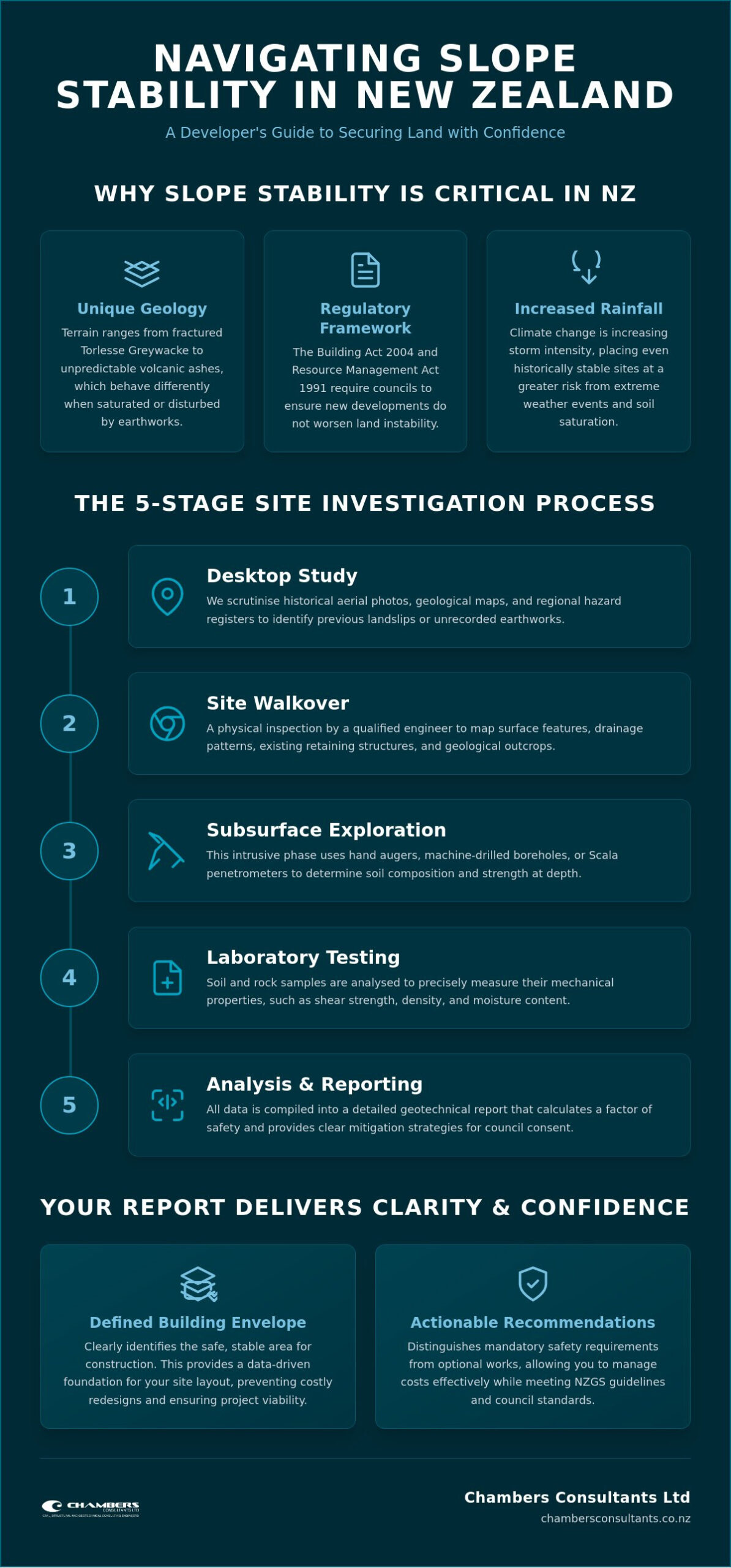
- Understand how New Zealand’s unique geological features, such as volcanic ash and Torlesse Greywacke, necessitate a comprehensive slope stability assessment NZ to secure your long-term property investment.
- Master the five critical stages of a professional site investigation, moving from historical record reviews to physical walkovers that map the hidden risks of your terrain.
- Learn to navigate the latest NZGS Slope Stability Guidance to ensure your project meets evolving regulatory standards and remains cost-effective through precise mitigation design.
- Acquire the skills to interpret technical geotechnical reports, allowing you to clearly define your building envelope and distinguish mandatory safety requirements from optional works.
- Recognise how a multi-disciplinary approach-combining surveying and geotechnical expertise-transforms complex land development puzzles into a clear, structured path for council consent.
What is a Slope Stability Assessment and Why is it Vital in NZ?
A slope stability assessment NZ is a systematic, scientific evaluation of ground conditions designed to determine if a landform can support development without failure. It’s more than a simple visual check; it’s a deep dive into the mechanical properties of soil and rock. Before breaking ground, it’s essential to understand What is Slope Stability? and how it dictates the safety of your project. This process identifies the forces that keep a slope intact versus the gravitational stresses that threaten to pull it down, providing a calculated factor of safety that informs every subsequent design decision.
New Zealand’s geology presents a unique set of challenges that demand this level of precision. Our terrain is a complex mosaic, ranging from the highly fractured Torlesse Greywacke found in many mountainous areas to the sensitive, unpredictable volcanic ashes prevalent in various parts of the country. These materials often behave differently when saturated or disturbed by earthworks. While a hillside might appear serene, a geotechnical engineer looks beneath the surface to identify latent hazards such as relic slip planes or sensitive soil layers that could be triggered by construction activity or seismic events.
The legal imperatives for these assessments are clear and non-negotiable. Both the Building Act 2004 and the Resource Management Act 1991 place a heavy emphasis on the management of natural hazards. Councils are legally required to ensure that any new development won’t be subject to, or worsen, land instability. By commissioning a slope stability assessment NZ early, you’re not just ticking a box; you’re protecting your financial investment and ensuring the long-term safety of the site’s future occupants.
Recognising the Signs of Potential Instability
Nature often leaves clues before a significant failure occurs. Visible indicators like tension cracks in the soil, “drunken” or leaning trees, and hummocky, uneven ground are classic signs of active or historical movement. Historical land use, such as poorly compacted fill from previous decades, can also create hidden vulnerabilities. As climate change increases storm intensity across New Zealand, even sites that have been stable for generations are facing new risks from extreme rainfall, making professional oversight more critical than ever.
The Regulatory Framework: Council Consent Requirements
Navigating council requirements often involves understanding Section 72 of the Building Act. This section allows councils to grant building consents on land subject to natural hazards, provided the work doesn’t accelerate the risk, though it often results in a permanent notice on the property title. For subdivisions, a stability report is a cornerstone of the Resource Consent application. Engaging geotechnical experts during the initial feasibility phase prevents the frustration of costly redesigns or project halts during the formal consenting process.
The 5 Key Stages of a Professional Site Investigation
A professional slope stability assessment NZ follows a rigorous, five-stage protocol to transform raw terrain into a data-driven development plan. This isn’t just a site visit; it’s a forensic investigation of the land’s history and its future potential. By following a structured methodology, engineers can identify risks that aren’t visible from the surface, ensuring that your project stands on a foundation of certainty rather than guesswork.
The process moves logically from broad research to site-specific technical data. This sequential approach ensures that every investigation is tailored to the unique geological nuances of the property. The five stages include:
- Desktop Study: Scrutinising historical aerial photography, geological maps, and regional hazard registers to identify previous landslips or unrecorded earthworks.
- Site Walkover: A physical inspection by a qualified engineer to map surface features like drainage patterns, existing retaining structures, and geological outcrops.
- Subsurface Exploration: The intrusive phase where we look beneath the surface using hand augers, machine-drilled boreholes, or Scala penetrometer tests to determine soil strength at depth.
- Laboratory Testing: Analysing soil samples in a controlled environment for moisture content, shear strength, and plasticity to understand their mechanical behaviour.
- Engineering Analysis: Building a computerised model using the gathered data to calculate the Factor of Safety (FoS) and determine if the site meets building standards.
Fieldwork: What Happens on Your Property?
Property owners often worry about the disruption caused by site investigations. We distinguish between non-invasive mapping, which leaves the ground untouched, and intrusive testing. For many residential projects, we use portable hand tools like hand augers to minimise impact on the landscape. However, more complex sites or larger developments may require heavy-duty drilling rigs to reach deeper strata. Our team prioritises managing site access carefully, ensuring we protect existing vegetation and structures while gathering the necessary data. If you’re unsure about the requirements for your specific site, our slope stability assessment services can provide a tailored investigation plan.
Data Analysis: Calculating the Factor of Safety
The “Factor of Safety” (FoS) is the numerical cornerstone of your report. Simply put, it’s the ratio of the forces resisting a landslide to the forces driving it. An FoS of 1.0 means the slope is at equilibrium; any additional weight or water could trigger a collapse. Councils typically require a higher margin, often 1.5 for long-term stability. Our analysis aligns with the GNS Science Landslide Planning Guidance, simulating “worst-case” scenarios such as extreme 1-in-100-year rainfall events or significant seismic activity. This data culminates in an Engineering Geological Model, a conceptualisation that guides your architects and structural engineers toward a safe design.
Understanding NZGS Guidelines: Translating the Technical Units
The New Zealand Geotechnical Society (NZGS) recently overhauled how land hazards are managed with the rollout of the Slope Stability Guidance (SSG). Starting with Unit 1 in November 2024 and continuing through 2025, these units represent the most significant shift in industry standards in recent decades. For a developer or homeowner, these aren’t just academic papers; they are the mandatory blueprint your engineer must follow to ensure your slope stability assessment NZ is accepted by the local Council. Adherence ensures approval. This transparent framework removes the ambiguity often found in older, less structured reporting methods.
Industry professionals stay aligned with these evolving standards through “Geomechanics News” and regular symposiums. This continuous update cycle ensures that the advice you receive reflects the latest seismic and climatic data. When your engineer references a specific “Unit,” they are aligning your project with a national consensus on safety and resilience. This alignment is vital for securing insurance and meeting the stringent criteria set by authorities like Auckland Council, which recently clarified its requirements for Factor of Safety in June 2025. It transforms a technical necessity into a strategic advantage for your development.
Mitigation and Design Principles (Unit 4)
Unit 4 is perhaps the most critical for your budget as it dictates the physical works required on your site. The guidance follows a strict hierarchy of risk management, prioritising the avoidance of hazards where possible. If building on a specific part of the slope is deemed too risky, the focus shifts to engineering solutions. These might include reinforced concrete retaining walls, palisade walls with deep-set piles, or high-tensile ground anchors that “stitch” the soil to more stable underlying rock. A sophisticated design balances these structural requirements with your aesthetic vision, ensuring that safety doesn’t come at the expense of your property’s natural character or environmental footprint. Precision in this phase prevents the over-engineering that often inflates construction costs.
Debris Flow and Rockfall Assessment (Unit 6)
While most people associate instability with slow-moving landslips, Unit 6 addresses more violent, fast-moving events. Debris flows and rockfalls present unique challenges, particularly in New Zealand’s alpine or volcanic regions. Traditional retaining walls may be insufficient for the energy of a debris flow, requiring specialised deflection barriers or catchment fences. By utilising advanced computer modelling, engineers can predict the path and velocity of potential falls. This level of foresight protects not just your residential assets, but also the critical infrastructure that services your land, providing a comprehensive layer of security against New Zealand’s most dynamic geological threats.
Interpreting Your Geotechnical Report: A Guide for Developers
Receiving your completed geotechnical report marks a pivotal moment in your development journey; it’s the bridge between a conceptual vision and a buildable reality. This document translates the findings of your slope stability assessment NZ into a practical framework that your architect and lead contractor will rely upon. It’s essential to view this report not merely as a hurdle for council consent, but as a strategic asset that defines the safest and most cost-effective path forward for your project.
A high-quality report distinguishes between mandatory requirements and suggested improvements. Mandatory works are those necessary to meet the New Zealand Building Code and secure your Section 72 or Resource Consent. Suggested works, however, often focus on enhancing the long-term resilience of the site beyond the minimum legal threshold. Understanding this distinction allows you to prioritise your budget effectively. While the report provides a robust scientific basis for construction, it’s vital to recognise that no geotechnical investigation can offer a 100% guarantee against nature. The earth is dynamic, and even the most thorough report is based on professional interpolation between test points.
Providing this report to earthworks and foundation contractors is the most effective way to secure accurate, competitive quotes. Without clear geotechnical data, contractors often include a “risk premium” in their pricing to cover unforeseen ground conditions. By presenting a definitive assessment, you eliminate the guesswork, allowing for precise calculations of pile depths, retaining wall volumes, and drainage requirements. If you’re ready to move from assessment to action, our team offers specialised foundation design services to ensure your structural plans align perfectly with your land’s unique profile.
The Building Envelope and Risk Zones
The “Building Envelope” is the specific area on your topographic survey where the engineer has determined it’s safe to build. This zone is established by mapping high, medium, and low-risk areas based on the gathered data. Engineers calculate setback distances from slope crests or toes to ensure that any potential minor movement won’t compromise the structure. This envelope directly dictates your architectural floor plan, influencing where heavy loads can be placed and where lighter, non-habitable structures might be more appropriate.
Foundation and Retaining Requirements
Your report will specify the foundation types required to bridge the gap between the surface soil and more competent ground. This might involve deep bored piles that “socket” into stable rock or shallow footings on improved ground. Managing water is the most critical factor in maintaining stability on New Zealand’s hillsides. Subsoil drainage is the essential component for mitigating the buildup of hydrostatic pressure that often leads to slope failure. Without effective drainage, even the most robust retaining wall can be undermined by the weight of saturated soil.
Securing Your Land with Chambers Consultants Ltd
Choosing the right partner for your land development journey is a decision that dictates the safety and financial viability of your project. With over 50 years of experience navigating New Zealand’s most challenging topography, Chambers Consultants Ltd stands as a stabilising force in an often unpredictable industry. We’ve spent decades refining our methodologies to ensure that every slope stability assessment NZ we conduct is rooted in meticulousness and absolute precision. Our legacy isn’t just built on technical data; it’s founded on the long-term trust of clients who require a steady hand to guide them through intricate geological puzzles.
We transform complexity into clarity by acting as seasoned mentors rather than distant technicians. Many property owners feel overwhelmed by the sheer volume of engineering jargon and regulatory requirements. Our role is to distil this information into a clear, actionable roadmap that aligns with your specific vision. This collaborative expertise ensures that the technical wisdom we possess remains focused on your project’s goals, allowing you to move from the initial site investigation to the construction phase with peace of mind and security.
The Advantage of Integrated Surveying and Engineering
Project friction often arises when different consultants work in silos, leading to miscommunications and delays. We solve this by integrating our land and subdivision development surveying expertise directly with our geotechnical and structural engineering services. This multi-disciplinary approach allows our surveyors to inform the geotechnical investigation from the very beginning, ensuring that the ground testing is perfectly aligned with the proposed lot boundaries and infrastructure layout. By housing all technical wisdom under one roof, we streamline the Resource Consent process and provide a cohesive project management experience that reduces both time and cost for our clients.
Your Partners in Land Development
Our commitment to your project extends far beyond the delivery of a single report. We provide a comprehensive suite of services that covers the entire lifecycle of land development, from initial site investigations to seismic design and retrofitting. Whether you’re a residential owner looking to secure a single hillside section or a commercial developer managing a large-scale subdivision, we offer the strategic thinking required to mitigate risks effectively. We value precision and forward-thinking innovation, ensuring that your development is grounded in traditional engineering excellence while embracing modern, efficient methodologies. To take the first step toward a secure and compliant development, organise your slope stability assessment with Chambers Consultants Ltd today.
Grounding Your Vision with Precision
Deciphering the technicalities of a slope stability assessment NZ is the first step toward transforming challenging terrain into a secure building site. You now have the roadmap to navigate the five stages of investigation and the latest NZGS guidelines with confidence. By understanding your building envelope and prioritising subsoil drainage, you can move forward with a clear strategy rather than uncertainty. This technical clarity is the foundation upon which safe, resilient developments are built.
At Chambers Consultants Ltd, we’ve been navigating these complexities since 1974. Our multi-disciplinary team of engineers and surveyors brings decades of local expertise to every project, specialising in seismic design and comprehensive risk mitigation. We don’t just provide reports; we provide a steady hand to ensure your investment is built on a foundation of integrity. Partner with Chambers Consultants Ltd for your next land development project to secure a roadmap tailored to your specific needs. Your vision deserves the precision and reliability that only a seasoned partner can provide.
Frequently Asked Questions
How much does a slope stability assessment cost in NZ?
The investment required for an assessment varies based on the site’s complexity, its accessibility, and the level of intrusive testing needed to secure accurate data. A standard residential assessment on a moderate slope involves a desktop study and site walkover, whereas projects on steeper terrain requiring machine-drilled boreholes or laboratory soil testing will involve higher costs. It’s best to view this as a necessary insurance policy that prevents far more expensive foundation failures or project delays during the council consenting phase.
Can I build on a slope that has a history of minor slips?
Building on land with a history of instability is often possible provided that a robust engineering mitigation strategy is implemented. A slope stability assessment NZ identifies the underlying cause of previous slips and provides the technical data needed to design specialized foundations or retaining structures. Success depends on the engineer’s ability to “stitch” the building into stable underlying strata, effectively bypassing the unstable surface layers to ensure long-term security.
How long is a geotechnical report valid for in New Zealand?
Most New Zealand councils and insurers consider a geotechnical report current for three to five years from the date of issue. However, this validity can be shortened if significant site changes occur, such as major earthworks on neighbouring properties or extreme weather events that alter the ground profile. If your report is older, a brief site re-evaluation is usually required to confirm that the original conclusions remain valid under current geological conditions.
What is the difference between a site investigation and a stability assessment?
A site investigation is the physical act of gathering data through drilling and testing, while a stability assessment is the analytical process of interpreting that data. Think of the investigation as the collection of evidence and the assessment as the strategic verdict that determines how you can safely develop the land. Both are necessary to form a complete picture of how the ground will behave under the stresses of construction and seismic events.
Do I need a slope stability report for a simple retaining wall?
Requirements depend on the height of the wall and the nature of the slope it supports. Generally, walls over 1.5 metres in height or those supporting a surcharge load, such as a driveway or a building foundation, require a building consent and a supporting geotechnical report. even for smaller walls, an assessment ensures that the structure doesn’t inadvertently trigger a larger failure by altering the slope’s natural drainage or weight distribution.
Will a slope stability assessment affect my insurance premiums?
A professional assessment often provides the security that insurers need to offer coverage on challenging or hillside sites. While identifying a hazard might seem concerning, a report that includes a certified mitigation design demonstrates that the risk is being managed effectively through professional engineering. Transparency with your insurer, backed by authoritative data, is the most reliable way to secure your property’s future insurability and peace of mind.
What happens if the report finds the land is unstable?
Finding instability isn’t the end of a project; it’s the beginning of a more informed and safer design phase. Our engineers specialise in solving these puzzles by recommending specific foundation types, drainage systems, or retaining structures to stabilise the site. We transform the problem into a resolution, providing a clear path forward that meets council safety standards while protecting your investment from future land movement.
Can I perform my own preliminary slope check?
You can certainly look for surface indicators like tension cracks, leaning trees, or uneven ground, but these observations don’t replace a professional slope stability assessment NZ. Latent hazards often exist deep underground, invisible to the untrained eye and only detectable through subsurface exploration. A professional evaluation uses specialised equipment and mathematical modelling to identify risks that simple visual checks will always miss, ensuring your safety isn’t left to chance.