

A single oversight in geotechnical mapping can stall a multi-million dollar project before the first spade hits the dirt. You’ve likely felt the pressure of managing escalating costs, with cement prices rising 7.7 per cent over the last year, while simultaneously trying to satisfy the stringent requirements of New Zealand’s resource consent process. It’s a delicate balance that requires more than just technical skill; it demands a strategic approach to infrastructure development services that anticipates seismic risks and terrain instability from the outset. Precision is the only safeguard against uncertainty.
We understand that the path from a conceptual site plan to a finished structure feels increasingly fraught with regulatory and environmental hurdles. This guide provides the clarity you need to master these modern complexities, offering professional engineering and surveying insights specifically tailored for the unique challenges of the New Zealand landscape. You’ll gain a clear roadmap that moves methodically from initial site investigations to project completion, ensuring your next development stands on a foundation of precision and long-term structural integrity.
Key Takeaways
- Define the professional scope of infrastructure development services and understand how the vital link between surveying and engineering underpins project viability.
- Discover how integrating precise topographic data with structural design prevents costly construction re-works and ensures long-term integrity.
- Learn to mitigate New Zealand’s specific geological risks through professional slope stability assessments and seismic-resilient foundation design.
- Gain a clear, step-by-step roadmap for navigating the entire development lifecycle, from initial site feasibility to final technical execution.
What are Infrastructure Development Services?
Infrastructure is the skeleton of a functioning society, but the term often masks the sophisticated technical framework required to bring a project to fruition. Professional infrastructure development services provide the intellectual and technical scaffolding that supports every successful build. It’s not simply a matter of pouring concrete or laying pipes; it’s the meticulous coordination of engineering wisdom and surveying precision to ensure a project is both legally viable and physically enduring. This Infrastructure-based development approach acts as a primary driver for growth, provided the initial planning is grounded in reality.
A multi-disciplinary strategy represents the gold standard for complex modern projects. When land surveying, engineering, and environmental management services are integrated from day one, the risk of technical friction disappears. This collaborative model is especially crucial in New Zealand, where the landscape demands a deep respect for natural topography and environmental stewardship. By addressing sustainability early, we ensure that infrastructure doesn’t just serve the present, but remains a stable asset for future generations.
The Core Pillars of Infrastructure Engineering
Success begins with three fundamental pillars. Civil works design focuses on the essential arteries of a site, managing earthworks, roading, and drainage systems to ensure efficient site function. These systems are only as strong as the structural integrity that supports them. In our local context, this means ensuring assets can withstand both the passage of time and the sudden violence of seismic events. Geotechnical foundations represent the final, perhaps most critical pillar. The ground beneath defines every possibility for the project above, making expert soil analysis and slope stability assessments non-negotiable for long-term security.
Why Professional Consultancy Matters in 2026
The regulatory landscape is increasingly complex. Navigating the latest reforms in resource consent and zoning requires a steady hand and a deep understanding of local council expectations. A professional consultant doesn’t just fill out forms; they mitigate multi-million dollar risks by identifying potential geotechnical failures or seismic vulnerabilities before they manifest as costly delays. With construction input prices having seen a 12.6 per cent annualised increase in early 2026, there is no room for error. Strategic infrastructure development services allow you to move from a conceptual vision to an actionable engineering blueprint with confidence, transforming intricate puzzles into clear, structured paths forward.
Integrating Engineering and Surveying for Project Success
Effective civil projects hinge on the seamless transition from raw data collection to structural execution. Surveying and engineering aren’t simply adjacent fields; they are the building blocks of development that must operate in a state of constant feedback. When infrastructure development services are delivered through a unified lens, the physical truth of the land informs every subsequent design decision. This prevents the expensive re-works that occur when engineering assumptions clash with the reality of the terrain. Precision is everything. If a topographic survey is out by even a few centimetres, the entire drainage gradient of a site could be compromised, leading to significant remedial costs.
Managing environmental impacts through precise site investigation allows us to protect the landscape and the project’s viability simultaneously. In subdivision development, this coordination is particularly vital. It serves as a practical case study in multi-disciplinary alignment, where the surveyor’s boundary data and the engineer’s structural requirements must exist in perfect harmony to secure council approval. Identifying geotechnical constraints early through professional site investigation allows for a design that respects the natural terrain rather than fighting it.
Land and Subdivision Surveying
The journey from a raw parcel of land to a legally titled subdivision is a complex arc where the surveyor serves as the primary navigator. Accurate boundary and topographic data ensure that every lot is viable and every road alignment is compliant with local standards. By utilising advanced surveying technology, we map intricate contours and existing services with absolute fidelity. This groundwork is the essential precursor to any land and subdivision development surveying effort, providing the clarity required for the engineering phase to begin without hesitation.
Civil Design: Roading, Drainage, and Utilities
Once the terrain is mapped, the focus shifts to crafting the technical solutions that make a site habitable. Designing robust roading networks and wastewater systems requires a deep understanding of New Zealand’s environmental standards and often challenging topography. Earthworks design is critical; it’s the art of balancing cut and fill to create stable building platforms while minimising site disturbance. Comprehensive infrastructure development services must also address these invisible networks, ensuring that drainage and utility systems are designed for resilience and longevity. Partnering with a multi-disciplinary team like Chambers Consultants Ltd ensures that these technical threads are woven together from the earliest feasibility stages.
Managing Risk: Geotechnical and Seismic Resilience
Our nation’s diverse geography presents both opportunities and challenges. From the fractured fault lines of geologically active zones to the soft, alluvial soils of our various plains, the ground is rarely a static platform. Effective infrastructure development services must prioritise resilience against these natural forces. It’s not enough to design for the average day; we must engineer for the worst-case scenario. This requires a deep technical understanding of how different soil profiles behave under stress, ensuring that every structure remains grounded regardless of seismic activity or extreme weather. Precision is the only safeguard against the unpredictable.
Managing these risks involves a proactive stance. By identifying geotechnical vulnerabilities during the feasibility stage, we prevent minor soil issues from escalating into structural failures. This strategic foresight protects both the physical asset and the financial investment, providing a sense of security that only comes from decades of engineering wisdom. We treat every site as a unique puzzle where the solution lies in the perfect alignment of data and design.
Slope Stability and Geotechnical Hazards
Landslips represent a significant threat to infrastructure continuity in hilly regions. Professional slope stability assessments use a methodical approach to identify slip planes and saturation risks before they become catastrophic failures. By employing engineering solutions like retaining structures and sophisticated erosion control, we remediate vulnerable land and secure its future. A robust geotechnical report is often the deciding factor in building consent success. It provides the council with the necessary assurance that the site is safe for development and that the proposed works won’t compromise the surrounding terrain.
Seismic Retrofitting and Structural Upgrades
Protecting existing commercial assets is just as vital as new construction. Seismic design and retrofitting allow older structures to meet modern safety requirements without the need for total demolition. In 2026, simply meeting the minimum building code is often insufficient for long-term asset protection. We focus on upgrades that secure asset value by exceeding these standards, using high-precision structural analysis to identify weak points. This strategic retrofitting process transforms vulnerable buildings into resilient hubs, offering peace of mind to owners and tenants alike. It’s a collaborative effort to preserve the past while securing the future.
Foundation design serves as the final line of defence. Every site requires a custom solution, whether it’s deep piling for reclaimed land or raft foundations for areas prone to liquefaction. By integrating these geotechnical insights into the broader scope of infrastructure development services, we ensure that the project is built on a foundation of absolute certainty. We don’t just build; we ground your vision in reality.
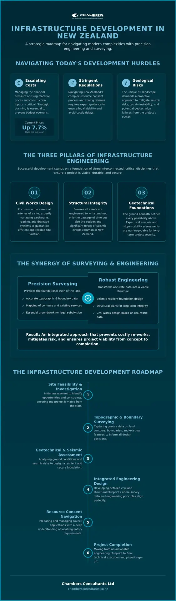
The Infrastructure Development Process: A Step-by-Step Roadmap
The journey from a blank site to a commissioned asset is a methodical progression that leaves no room for guesswork. In an industry where overall construction input prices rose by 9.6 per cent in the year leading to May 2026, efficiency is as much a financial necessity as it is a technical one. Comprehensive infrastructure development services provide the framework for this transition, ensuring that every phase of the project is grounded in data and guided by statutory expertise. By following a structured roadmap, you transform a high-risk venture into a predictable, manageable sequence of milestones.
This process isn’t merely a checklist; it’s a strategic evolution. It begins with a deep interrogation of the land and culminates in the final certification that proves your vision has been realised to the highest engineering standards. Each step is designed to build upon the last, creating a cumulative layer of certainty that protects your capital and the community’s safety. Precision at the outset prevents the compounding of errors that typically leads to budget overruns or consent delays.
Phase 1: Investigation and Feasibility
Before a single dollar is committed to physical works, the land must be interrogated. Is the project actually viable? Conducting geotechnical site investigations and soil testing is the only way to reveal the hidden characteristics of the terrain, such as hidden water tables or low-bearing capacity. Preliminary surveying establishes the hard site constraints, mapping boundaries and existing services that will dictate the project’s layout. This phase is about identifying potential environmental and structural roadblocks early, allowing for design adjustments before they become expensive problems. It’s the stage where we separate ambition from reality.
Phase 2: Design, Consent, and Execution
With the site constraints mapped, the focus shifts to crafting the technical solution. This involves developing detailed civil and structural engineering plans that address roading, drainage, and foundation requirements. Liaising with local authorities is often the most taxing part of the development lifecycle; however, a professional approach to the Resource Consent and Building Consent maze ensures smooth approvals. Once construction begins, the role shifts to technical oversight. Providing construction observation ensures that the physical build matches the engineering design, leading to the final certification required for project sign-off. If you’re ready to move from concept to completion, you can partner with Chambers Consultants Ltd to navigate this roadmap with absolute confidence.
Chambers Consultants Ltd: Decades of Engineering Wisdom
Stability is the hallmark of enduring infrastructure. For over 50 years, Chambers Consultants Ltd has provided the technical wisdom and steady leadership required to navigate New Zealand’s most challenging terrains. We’ve built a legacy on the belief that precision isn’t just a goal; it’s a responsibility. Our team thrives on transforming intricate engineering puzzles into clear, actionable paths forward, ensuring that every project is grounded in integrity and technical excellence. This long-standing experience allows us to offer infrastructure development services that are as reliable as they are innovative. We act as a seasoned mentor for our clients, providing the clarity needed to turn ambitious visions into structural realities.
The value of a multi-disciplinary partner cannot be overstated. When land surveying, geotechnical assessment, and structural engineering are housed under one roof, the potential for communication gaps vanishes. This integration is why we’ve become a preferred partner for national projects that require a high degree of coordination and technical depth. We don’t just provide data; we provide strategy. Every site investigation and design blueprint is crafted with the understanding that long-term asset value depends on the meticulousness of the initial work. We pride ourselves on being a stabilising force in a demanding industry, offering a steady hand from the first soil test to the final sign-off.
Our Integrated Service Model
Complexity often leads to friction, especially when multiple consultants operate in isolation. Chambers Consultants Ltd eliminates this risk by providing a single point of truth for your project. By seamlessly combining geotechnical analysis, structural design, and land development expertise, we ensure that every technical thread is aligned. This holistic approach doesn’t just improve efficiency; it provides total peace of mind. We manage the technical risks so you can focus on the broader vision, knowing that the foundation of your investment is secure. Whether it’s seismic retrofitting or a complex subdivision, our integrated model ensures that no detail is overlooked and no risk is left unmitigated.
Partnering for the Future of New Zealand
The challenges of 2026 demand a forward-thinking mindset. Chambers Consultants Ltd is committed to building resilient infrastructure that survives the test of time and nature, with a strong focus on sustainable environmental management. As global industry trends shift toward decarbonisation and climate resilience, we ensure New Zealand projects remain at the cutting edge of durability and compliance. We don’t just design for today; we engineer for generations. Our commitment to future-proofed design means anticipating the needs of tomorrow’s communities while respecting the traditional foundations of our industry. To begin your journey toward engineering excellence, organise a consultation with our expert team.
Securing Your Legacy Through Engineering Precision
Success in 2026 requires more than technical ability; it demands a strategic alignment of multi-disciplinary insights from the very first soil test. You’ve seen how integrating precise topographic data with robust structural design prevents costly re-works and ensures your project remains viable within New Zealand’s complex regulatory framework. By prioritising seismic resilience and professional slope stability assessments, you aren’t just building for today. You’re safeguarding a long-term asset against the unique geological challenges of our landscape. Precision is the only way to transform uncertainty into a clear, structured path forward.
Navigating these intricacies is simpler with a seasoned mentor by your side. Since 1974, we’ve provided the steady hand and technical wisdom required to deliver comprehensive infrastructure development services that stand the test of time. With over 50 years of industry experience across geotechnical, structural, and surveying disciplines, our team is ready to ground your vision in reality. Partner with Chambers Consultants for your next infrastructure project and gain the peace of mind that comes from decades of proven excellence. Let’s build a resilient future together.
Frequently Asked Questions
What exactly do infrastructure development services include?
These services encompass the full technical lifecycle of civil works, including land surveying, geotechnical assessment, structural engineering, and environmental management. They provide the professional consultancy required to ensure that project components like roading, drainage, and utilities are technically sound and compliant with local regulations. It is a multi-disciplinary approach designed to transform raw land into functional, serviced environments that stand the test of time.
How much does a geotechnical report for building consent cost?
Costs for a geotechnical report vary significantly based on the site’s complexity, the extent of subsurface testing required, and the specific terrain challenges. Every project is unique; therefore, we recommend obtaining a site-specific quote rather than relying on general industry estimates. Factors such as slope stability and soil profile variability directly influence the scope of investigation needed to satisfy council requirements for building consent.
Why do I need both a surveyor and an engineer for my subdivision?
Surveyors define the legal boundaries and topographic features, while engineers design the physical systems that make the land habitable. Without accurate surveying data, an engineer cannot design compliant roading or drainage gradients. This partnership ensures that your subdivision is not only legally titled but also physically stable and serviced according to modern engineering standards; it is a vital link for project viability.
Can you help with seismic retrofitting for older commercial buildings?
We specialise in seismic design and retrofitting to bring existing commercial assets up to modern safety standards. Our process involves a detailed structural analysis to identify vulnerabilities, followed by the design of custom upgrades that secure the building’s integrity. This strategic investment protects both the occupants and the long-term asset value in New Zealand’s seismically active environment, providing total peace of mind for property owners.
How long does the infrastructure design and consent process typically take?
The timeframe generally ranges from several months to over a year, depending on the scale of the project and the speed of local council processing. Initial site investigations and the engineering design phase might take eight to twelve weeks. However, the resource consent phase is subject to statutory timeframes and potential requests for further information, making early engagement with professional infrastructure development services essential for maintaining project momentum.
What is the role of environmental management in land development?
Environmental management ensures that development activities do not compromise the surrounding ecosystem or breach statutory protections. This includes managing stormwater runoff, controlling erosion, and ensuring compliance with regional environmental plans. By integrating environmental management services early, we help clients avoid legal complications and ensure their projects contribute to a sustainable and resilient local landscape, protecting both the environment and the investment.
Do you provide services for both residential and commercial infrastructure?
Our multi-disciplinary team provides professional consultancy for both large-scale commercial developments and residential subdivisions. Whether we’re designing foundation design services for a commercial warehouse or managing the land surveying for a new housing estate, our focus remains on precision and stability. We tailor our engineering solutions to meet the specific demands and regulatory requirements of each sector, ensuring a high professional register across all projects.
How does Chambers Consultants Ltd manage slope stability risks?
We manage these risks through a methodical process of slope stability assessment services that identify potential failure planes before construction begins. Our engineers use sophisticated mapping and soil testing to design remediation strategies, such as retaining structures or drainage improvements. This proactive approach ensures that building platforms remain secure and that the risk of future landslips is effectively mitigated, grounding your vision in technical certainty.